
A river that doesn’t divide the city, but rather connects the banks
Industry experts at the Institute of the General Plan of Moscow — the organizer of the international competition for the development of the adjacent areas of the Moscow River — spoke about the transport and environmental components of the future concept.
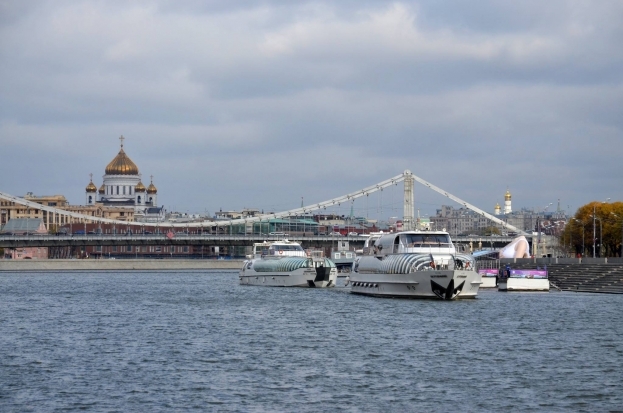
Reporters went along with the Institute experts on the short journey down the river from the pier at the Moscow-City International Business Center to the ZIL peninsula.
Compared to other rivers, which form the urban planning axis of the biggest European cities, the Moscow River is quite impressive in length: the length of the river within the city is 76 km. For comparison, the main waterway of Berlin has a length of 35 km, New York City — 37 km, London — 64 km, Shanghai — 83 km. However this certainly is not the only thing that is making the current concept of integrated development of Moscow River’s coastal areas a critical urban development milestone. “Bringing order” to the river cuts across a number of acute problems throughout the city, such as the creation of green and public spaces on the waterfront, the development of pedestrian and bicycle routes, and improved landscaping design.
An important factor is the permeability of the river. Currently the waterway is largely separated from the city by roads. The competition participants should provide pedestrian access to the river, and descents to the water at both artificial and natural embankments.

“The Moscow River has great potential, but its capabilities are not fully utilized,” noted Andrei Gnezdilov, the chief architect of the Institute of General Plan of Moscow. “The river divides the city into two parts, when it should be linking the banks: both visually and in terms of transport and pedestrian linkages. To eliminate this contradiction is one of the tasks for the contestants.”
Passenger Moscow River
Presently the Moscow River has both freight and to a lesser extent passenger transport, which is mainly touristic. The contestants have been advised to keep the volume of cargo at about 9 million tons per year and to give suggestions for the amount of passenger volume, said Sergey Kanep, the head of the traffic department at the Institute of General Plan of Moscow.
To use the river as an alternative to city transport, including both private vehicles and public transportation, contestants should include a number of factors: the existing berthing facilities, the need for new ones, the convenience of transferring to other transport modes, approaches to the river with convenient and well-lit walkways, and safe crosswalks across roads.
Thus, according to the expert, new water routes can be generated from the peripheral part of the city to the center. Of course, such transport solutions should be closely linked with the prospects of developing the surrounding areas and the existence of transport demand.

As for the vehicular traffic along the embankments it is impossible to go without it, especially in the central part of the city. Using transport models, experts of the Institute of the General Plan came to the conclusion: if embankments will be made pedestrian, the redistribution of traffic flows will lead to the collapse of the adjacent road networks. For example, simply closing the Kremlin Embankment to cars will make the center of Moscow, the Boulevard and the Garden Ring, to come to a complete standstill. But at abandoned industrial areas from the Third Ring Road to the MKAD Ring Road, the embankments will mainly perform a recreational, pedestrian function. There will be bike lanes, and moreover the bike routes will be continuous, and will not be limited to embankments and will continue on through the city.

Connecting the Banks
An important issue that the contestants have to develop in their concepts is the transport and pedestrian connectivity of the banks. The Moscow River currently has 36 bridges (for comparison, in Berlin with a river shorter in length, there are 45 bridges), and the distance between them is 430 m to 6 km. The numbers speak for themselves — the river is clearly lacking cross-connections. As Ekaterina Chernashkina, chief specialist of the road network development workshop at the Institute of the General Plan commented, the area from the Moscow-City International Business Center up to Andropov Avenue is the most favorable in this respect. There are 14 bridges, and the average distance between them is about 3 to 4 km.

Problems with the connectivity of territories begin in the middle of the city, from Nagatinskiy bridge located in the Kolomenskoye region, to Besedinsky at the 19th km of the MKAD Moscow Ring Road. On a stretch of 13.7 km from Nagatinskiy bridge to Brateevsky bridge there is virtually no opportunity to go from one bank to the other by car, the expert said. Therefore, one of the contestants’ tasks is to identify new bridge locations, including pedestrian bridges.

Arranging a number of bridge crossings is already incorporated into design studies, including in the General Plan of Moscow, explained Chernashkina. A new bridge is projected for the 1905 Street area with access to the Taras Shevchenko embankment. Another bridge structure (in the event of the reorganization of the Varshavksaya industrial zone) may be erected in the vicinity of Leninskaya Sloboda Street. The General Plan also provides for the extension of the Simonovskaya embankment to Andropov Avenue with the construction of a high-level bridge over the existing backwater." As is the case with the new quays, the banks should be ready for the construction of bridges. If it is a former industrial area, it should be reorganized, and convenient pedestrian connections and well-developed approaches created," summed up the expert.
The River and Nature
The total area of natural habitats that are adjacent to the river is about 2,000 hectares. Approximately half of the green areas only require quality care according to Vasily Gritsan, the deputy head of the Ecology Research and Design Association of the Institute of General Plan of Moscow. Another thousand hectares, including the South River Port and Taras Shevchenko embankment, require reorganization and development of landscaping designs.

Meanwhile, there are some things that have already been realized: the first two stages of redeveloping Marinsky Park. And next on the agenda is the ZIL territory, where a huge 93 hectare park area will be created, the expert added.

The proposals are divided into three phases of implementation: before 2017, 2025, and 2035. In April 2015 the winning concept will be reviewed at a meeting of the Urban Planning and Land Commission in the presence of the Mayor of Moscow. According to the results, a list of first phase measures to be included in the city program for further implementation will be formed.
In a short interview with the Archcouncil of Moscow website, Sergey Kanep, the head of the traffic department at the Institute of General Plan of Moscow, spoke about some details of the transport part of the project:
— You said that along the embankments within the Garden Ring movement should be retained. But in other areas, such as industrial areas, new roads are planned?
— We have not given the contestants the task of creating new road arteries on coastal areas. Only the embankment along the ZIL factory will receive a transport function. With regard to industrial areas, on the periphery of the city for example, the embankments are to be used for recreational purposes: for footpaths and bicycle routes. Movement along the Moscow River within the Garden Ring should be retained, or another option is to slightly reduce it. But then you have to decide on how to redistribute traffic flows. If this task is completed, we will be able to shift priorities from transport to pedestrians and to arrive at what we are constantly talking about — opening the river to pedestrians.

— In your speech, you talked about the development of passenger transportation on the Moscow River. Do you support an increase in this type of transportation?
— The Moscow River should work fully. However, to develop passenger river transport, for example from residential areas to the center, corresponding infrastructure is needed. The Institute of the General Plan recommended that contestants generate about 30 new berthing facilities on the Moscow River. Significantly, they will mainly be where there is the possibility to change from water transport to high-speed off-street transport, or public ground transport. Additional berths are needed also at landmarks, and places of employment. Such studies, incidentally, are already being conducted by the city’s Department of Transportation on the proposal of the Moscow shipping company. The locations of future berths are being arranged according to the possibility of transferring to other transport modes.
— Your colleagues say that the river is difficult to use for passenger traffic since it is winding...
— River bends certainly create difficulties for high-speed traffic. However, a small portion of passenger traffic can be arranged. The main thing is that the river will be included in the capital’s transport system.
- Tags:
- competitions |
- Urban Design

